![]() |
| Oldest House Museum Map Exhibit with Boazio Map 1589 |
I just spent a fascinating two hours at the Oldest House Museum's new exhibit entitled
5 Centuries of Our Coast - A Visual History of the Nation's Oldest City and its Shores. This is a wonderful exhibit covering 500 years of St. Augustine maps in the Page Edwards Gallery at the Oldest House Museum Complex. The exhibit was created by Susan Parker and Megan Wilson.
I have always been fascinated by maps, especially very old maps and what they can reveal about the past. When I moved to St. Augustine, I had the pleasure of being introduced to the wonderful map collection at the St. Augustine Historical Society Research Library and Oldest House Museum. Carl Halbirt, the City Archaeologist, always uses maps as the first step in preparing to conduct an archaeological survey in the City. St. Augustine is blessed with a long chronology of maps depicting the European city through time. These maps are curated at the Library in a special room in large flat map drawers. In the past, with special permission and clean hands, one could gain access to this gold mine of information. As a volunteer with Carl, I could occasionally indulge my desire to immerse myself in the old maps of St. Augustine.
![]() |
| Albert Cantino's Planisphere Map from 1502 - first map to show the coast of Florida |
![]() |
| 2009 Satellite Image of the Gulf Stream |
But now, voila, reproductions and enlargements of the old maps are accessible to anyone with an interest in St. Augustine and its maps. The exhibit will be at the gallery for two years and is free to St. Johns County residents. The span of St. Augustine and Florida history covered by the maps in the exhibit begins with a 1502 map showing part of the coast of Florida and ends with a 21st century satellite image of the Gulf Stream.
I have volunteered on a number of St. Augustine archaeology projects in the past decade and most of them have benefited from a review of appropriate maps. Maps help archaeologists determine where to begin to excavate and how to interpret the data. University of Florida Archaeologist, Dr. Kathleen Deagan, has been excavating at the Fountain of Youth and Mission of Nombre de Dios since the 1970's. Early maps of the waterways and coast line helped her establish through archaeology where the City's founder, Pedro Menendez landed and settled and where the first Franciscan mission to the Timucua Indians, Nombre de Dios, was located.
![]() |
| Map of St. Augustine and Neighborhood by H.S. Wyllie 1898 |
Dr. Deagan says that the property maps of St. Augustine made during the 18th century are particularly helpful in doing archaeology at sites in the City. When St. Augustine transferred hands from Spanish to British rule in 1764, the Elixio de la Puente Map of the town's properties, was drawn to assist with the transfer of the town to the incoming English. Today it helps archaeologists establish the quarters or neighborhoods where the soldiers, craftsmen and government officials resided as well as the location of "Indian Towns" outside the town walls. Twenty years later, Florida was returned to Spanish rule. The Rocque Map of 1788, another property map of the town, was drawn. This map accurately documents the changes in configuration of the individual properties at the end of Florida's British period by showing lot lines, housing materials and ownership.
![]() |
| Plan of the Fort and City of St. Augustine, Florida by Juan Joseph Eligio de la Puenta 1764 |
![]() |
| Plano Particular de la Ciudad de San Agustin by Mariano de la Rocque 1788 |
Because the town tended to grow on the highest elevations, Lydar elevation maps help to trace the expansions of the old town over time.
![]() |
| Example of Lydar Map |
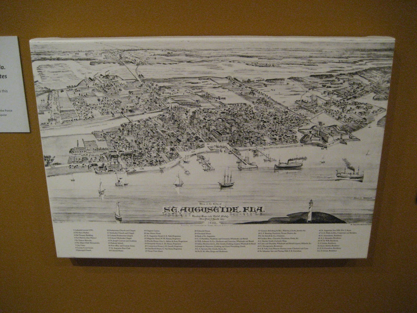
In our modern era, the Intracoastal Waterway opened up a highway for boating from New Jersey all the way to Miami. Maps of the Intracoastal from the Georgia line to St. Augustine are included in the exhibit. In the early 20th century Bird's Eye View maps and a series of Sanborn Insurance Maps of streets and buildings provided detailed information on the building footprints on lots and building additions and demolitions over time. All of this information assists archaeologist's in the planning and interpretation of excavations.
![]() |
| Intracoastal Waterway chart from Nassau Sound to Matanzas Inlet 1952 |
![]() |
| Bird's Eye View of the City of St. Augustine by Henry Wellge 1885 |
Maps are a window into the past and a great asset to archaeologists who can then fill in the details of life in colonial St. Augustine. I highly recommend a visit to the Oldest House Museum's St. Augustine map exhibit.
.